when: thursday august 19th 2010
where: Puget Sound / North Bend
participants: uncle and myself
driver: dave drove his prius
food: leftover cheeseburgers, peanut butter clif bar, brownies, orange, lettuce, peanut butter and jelly.
trail: the 3 year old trail has many switchbacks built in and is marked by a post at the end of each of the four miles. the previous trail was a "scamper" before the switchbacks were installed during a time of financial abundance and park revitalization.
views/weather: after the 3rd mile-marker the air was damp and misty. virtually no views, besides the rocks and pines on the mountain itself. it was freezing on top. i put on all the clothes i had in my pack.
notes: we originally planned to take three more people with us, but all of them decided not to come. we had more food in that case than we could eat. on top is this thing called 'the haystack' which a hundred foot dome of rock that you have to 'scamper' up to get on top of. it was wet so we didn't think we'd get all the way up but we went to take pictures and look at the rock groove that looks easiest to scale. when we came back to where we left our lunch a person told us a chipmunk was getting into our food. i looked at the bag that had the brownies in it and there were only two left and we had brought three. there were a lot of people on the trail as we came down. seems like a popular spot. you'd pass a group hiking up as you hiked down like every ten minutes.
elevation: 4,167, a relief of 3,200 ft.
8/28/10
Pebble Creek (Mt. Rainier)
where: mt rainier national park
who drove: dave ross drove his prius from mercer island, i drove back to mercer island.
participants: myself
food: just water
trail: 2.2 miles of paved walk, stone, gravel, 2x snowfields and occasional dry dirt.
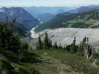
views/weather: you can see mt rainer and the cascades i guess. i don't really know this area. it was beautiful. you could see the niqually glacier and the giant canyon it has carved in mt. rainier. i think i saw mt st. helens. and something called like "jagged teeth" or "goats points," idk. you could really see in all directiosn except directly north because of the trails orientation to rainier which blocks the entire horizon. no clouds around rainier and just some haze around the surrounding ranges. the temperature, from memory, was 70 degrees.
notes: beyond pebble creek it becomes just snow field. signs recommend you don't go beyond pebble creek unless you have ropes and axes and crampons. the people on the trail: there are like lots of tourists, inexperienced hikers, young kids messing around in the snow, leaving water bottles on the ground. everyone had a camera. other people were collected in hiking parties and each carrying heavy backpacks. they seemed to be headed for camp muir which was a mile beyond pebble creek. from camp muir the typical plan is to leave at 2am the next day for the summit of rainier.
8/9/10
Jay Mt.
when: friday august 6th 2010
where: upper jay, essex county, ny
who drove: scott drove his hyundai from westport with us in it.
participants: scott, judy, alaina and myself.
food: tofu cheese with lettuce on whole wheat. corn chips. sliced carrot sticks. sliced and pitted peaches. corn chips. chocolate covered pomegranate pieces. tap water. wild blueberries. gluten-free chocolate graham crackers.
trail: 6 miles of unmarked herd path. windy, up and down. a few really steep parts. lots of roots and stones and trees to maneuver around. second half is an "open" ridge-traverse as opposed to the initial woods hiking.
views/weather: warm and breezy, drastic difference between when the sun was behind a cloud and when it wasn't. green mountains. whiteface mountain. high peaks. dix range. giant and rocky peak ridge. ausable and champlain valleys.
notes: we slept for like 20 minutes on top after lunch. crazy amounts of wild blueberries along the ridge, was just the right time i guess.
elevation: 3,600 feet. (2,100-plus vertical relief)
picture:
Subscribe to:
Posts (Atom)

